User Login
Login or Register in order to network with other Active ASPRS Members.
Home March 2013 Array of Sunshine
March 2013 Array of Sunshine

The 3D Elevation Program (3DEP) initiative is being developed to respond to growing needs for high-quality topographic data and for a wide range of other three-dimensional representations of the Nation's natural and constructed features. The primary goal of 3DEP is to systematically collect enhanced elevation data in the form of high-quality light detection and ranging (lidar) data over the conterminous United States, Hawaii, and the U.S. territories, with data acquired over an 8-year period. Interferometric synthetic aperture radar (ifsar) data will be collected over Alaska, where cloud cover and remote locations preclude the use of lidar over much of the State. The 3DEP initiative is based on the results of the National Enhanced Elevation Assessment.

To read more about the 3DEP program, please go to http://nationalmap.gov/3DEP/

 
March 2013 Array of Sunshine

The Florida Region intends to hold it's Annual Meeting colocated with the Annual Florida Surveying and Mapping conference taking place August 21st - 25th, 2013 at the Tradewinds Beach Resort in St. Petersburg, FL. Please plan on joining us at this meeting. Details to follow.

 
March 2013 Array of Sunshine

For those who dabble in GIS or do not have the full ESRI suite of software available, there is an affordable way to view spatial data and conduct rudimentary spatial analysis.  The ESRI ArcGIS Explorer 2500 allows you to view the already created online base maps and layers, access map services, and visualize information.  It also has added functionality to make great presentations.  Wow your co-workers, teachers, or your family with your ability to display data.  The software is free and available for download from the ESRI website at: http://www.esri.com/software/arcgis/explorer.  Your machine needs to have a minimum of 200 MB of free space, 2 GB of RAM, and the software will operate on 32 or 64 bit operating systems.  Not sure where to find data?  There are a variety of spatial data is available from public entities throughout Florida (www.fgdl.org) and at the Federal Government (http://datagateway.nrcs.usda.gov/ ). This application is a great way to start using GIS.  The best part about this software is it is all for free!

 
March 2013 Array of Sunshine

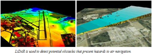
Federal agencies including the USGS, Natural Resources Conservation Service (NRCS), National Oceanic and Atmospheric Administration (NOAA), National Geospatial-Intelligence Agency (NGA), Federal Emergency Management Agency (FEMA), and the U.S. Army Corps of Engineers (USACE) are making significant investments in LiDAR data collection programs to support key missions. In addition, several states have either completed statewide projects or are actively planning LiDAR programs. Elevation data collection projects are usually coordinated with multiple funding organizations. Data acquisition projects are limited to the geographic areas where funding and common requirements coincide, and data consistency varies from project to project. These limitations can compromise any analysis over large geographic areas or any place an operational need crosses project boundaries. As LiDAR technology has gained widespread acceptance, and more organizations are considering acquisition programs, the need for coordination among the LiDAR user community has increased.


Read more...

 
March 2013 Array of Sunshine

A special congratulations to following individuals for being elected to their positions on the Florida Region Board of Directors. Brenda Burroughs, of Optech, and Kimberly Nale of eMap International  were both elected as Directors from 2013 until 2015.

Brenda Burroughs Kimberly Nale Jeff Young
 
March 2013 Array of Sunshine

The area below is represented by aerial imagery from three different web map providers, the local municipal property appraiser, Google Maps and Bing Maps.  Can you tell which image is the most recent? Which one is the oldest?

Click here for a higher resolution image. To vote, click here


March 2013 Array of Sunshine

For the 2013 Elections, there are two Director positions and one National Director position being voted on. Please click the "Read More" button below in order to read the biographies for the nominees.

The Polls will close at midnight Easten Standard Time, on Jan 31st, 2013.

In order to vote, you will need to:

Click Here to Log-In then Click Here to Vote

If you have any technical issues while attempting to vote, or need assistance ensuring that you are registered on our website, please email the webmaster This e-mail address is being protected from spambots. You need JavaScript enabled to view it or call 352-535-0307.


Read more...


Welcome to the Florida Region of  the American Society for Photogrammetry and Remote Sensing, where it is our goal to add value to your membership by bringing you the most relevant regional news and events. It is our mission to assist you in helping you obtaining your career objectives by facilitating networking events and increasing awareness of industry trends and technological improvements..


March 2013 Array of Sunshine

Below is an updated list of the Florida Region's Past Presidents

1958 George Rosenfield
1959 Harold Jury
1960 Harold Jury
1961 John Eichler
1962 John Eichler
1963 George Rosenfield
1964 George Rosenfield
1965 E. “Hank” Tasis
1966 Carleton Emery
1967 Carleton Emery
1968 L.A.D. Colvin
1969 L.A.D. Colvin
1970 Representative – James Latham (the issue doesn’t list a president)
1971 James Latham
1972 James Latham
1973 Randall Powell
1974 Randall Powell
1975 Norman Schile
1976 Byron Ruth
1977 Byron Ruth
1978 Byron Ruth
1979 John Strable
1980 Joel Kobelin
1981 Joel Kobelin
1982-1983 Ms. Janet D. Degner
1984-1985 Mr. Bob Evans
1986-1987 Mr. Chuck Woodward
1988-1989 Mr. Ed Comer
1990-1991 Mr. Gary Reed
1992-1993 Mr. Cornell Clapp
1994-1995 Mr. Gene Benware
1996-1997 Mr. Charlie Watts
1998-1999 Ms. Brenda Burroughs
2000-2001 Mr. Gary Florence
2002-2003 Mrs. Kathleen O’Keife
2004-2006 Mr. Drew Fisher
2007-2008 Dr. Al Karlin
2008-2009 Erin McCormick
2010-2011 Mr. Evan Brown